Wiser Imagery Services, LLC
  • Home
  • Services
    • GEOINT SERVICES >
      • GEOINT Production
      • Analysis as a Service
      • Intelligence Solutions
    • GEOSPATIAL SERVICES >
      • Satellite Imagery
      • Aerial Lidar
      • Mobile Lidar
      • Static Lidar
      • SUE - Underground Penetrating Lidar
      • Orthophotography
      • Aerial Triangulation
      • GIS
      • Digital Contour Mapping
  • MARKETS
    • GEOINT MARKETS
    • GEOSPATIAL MARKETS
  • PROJECTS
    • GEOINT Projects
    • Geospatial Projects
  • Who we are
    • Mission
    • History
    • Commitment to Quality
  • INSIGHT
    • Contract Vehicles
    • NAICS Codes
    • Partners
  • CAREERS
    • Career Opportunities
    • Benefits
    • Community Involvement
    • Culture
  • CONTACT
  • LOCATIONS
Wiser offers innovative solutions to clients in the public and private sectors. We combine technology and expertise to develop inventive solutions that deliver quality results and aid in critical decision making. With the flexibility and efficiency of a small business, we provide nimble responsiveness with the low risk and strong performance experience of an established GEOINT and Geospatial service provider.
GEOINT Services
GEOINT SERVICES
​Wiser has proven success in GEOINT SERVICES including analysis for Military and Intelligence Community customers, as well as specializing in relevant, quality, and time sensitive products. Wiser understands the needs of GEOINT customers by providing comprehensive solutions from utilizing our outstanding communication and commitment to quality.

​
The Wiser difference lies in our ability to anticipate movement in the fast-paced Information and Security world and accommodate this movement with diverse support capabilities. Achieving numerous “First-time Right” acceptances by the intelligence Community has demonstrated our commitment to our goal of 100% client satisfaction.
Geospatial Services
GEOSPATIAL SERVICES
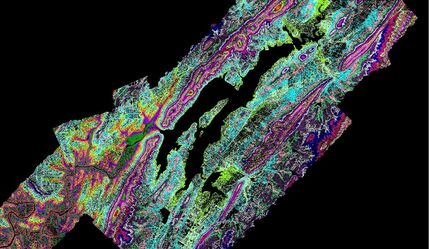
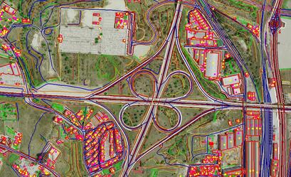
Wiser offers GEOSPATIAL SERVICES ranging from LIDAR using the latest in mobile and static laser scanning methods as well production of orthophotographs, digital feature data, and topographic elevation maps. Given the specifics of your project, we can select the most effective method and adapt to meet your changing needs.

​Our current clients have come to rely on our comprehensive staff of licensed and support professionals who are armed with an array of state-of-the-art equipment and techniques. Wiser is able to deliver valued solutions that prove to be accurate, cost effective, and efficient because of our extensive experience, proficiency in industry standards, and excellent rapport with clients and agencies.
GET IN TOUCH
Vertical Divider
CAREERS
Vertical Divider
SOCIAL MEDIA
We'd love to hear from you.
Contact Us
​
Vertical Divider
Join the Wiser Team.
View our current openings
Vertical Divider
  • Home
  • Services
    • GEOINT SERVICES >
      • GEOINT Production
      • Analysis as a Service
      • Intelligence Solutions
    • GEOSPATIAL SERVICES >
      • Satellite Imagery
      • Aerial Lidar
      • Mobile Lidar
      • Static Lidar
      • SUE - Underground Penetrating Lidar
      • Orthophotography
      • Aerial Triangulation
      • GIS
      • Digital Contour Mapping
  • MARKETS
    • GEOINT MARKETS
    • GEOSPATIAL MARKETS
  • PROJECTS
    • GEOINT Projects
    • Geospatial Projects
  • Who we are
    • Mission
    • History
    • Commitment to Quality
  • INSIGHT
    • Contract Vehicles
    • NAICS Codes
    • Partners
  • CAREERS
    • Career Opportunities
    • Benefits
    • Community Involvement
    • Culture
  • CONTACT
  • LOCATIONS